Selection of Aschbach, G. A.. (Date created: 1870, Date digitized: 2016-09-12, Date available: 2017-09-26). Topographical and Property Map of the City of Allentown and the Surrounding Territory.. [Still Image]. Retrieved from https://library.artstor.org/asset/SS7731862_7731862_12095277
Review Session
There is no new material to cover during today’s class. Rather, we will build from scratch our voter activity project, utilizing everything we have covered so far.
There will also be a demonstration of the mmqgis plugin which may be used to geocode street addresses. A Google Maps API key must be registered to use the mmqgis plugin.
To finalize your Voter Activity project, you will want to demonstrate most or all of the following:
- Configuring an XYZ Tiles layer connection, specifically, Google Satellite imagery tiles and Google Maps tiles, as well as OpenStreetMap tiles (pre-configured)
- Configuring one or more WMS (Web Map Services) connections, specifically PASDA provided boundaries like Pennsylvania county boundaries
- Configuring one or more ArcGIS REST Server connections, specifically Montgomery County voter district boundaries provided by the Montgomery County Mapping and Data Services Division
- Clipping selected voter districts and saving as a vector file (ESRI Shapefile)
- Select Features Using an Expression in QGIS by selecting only particular voter districts by name
- Using the Select Features tool to select only particular voter districts
- Creating “favorites” folders in the QGIS Browser panel
- Importing vector layers stored as compressed archives of files (e.g., ZIP files)
- Zooming to a selected thematic layer using the Zoom to Layer button
- Using the Symbology window to set the opacity, colors, and line width of polygons
- Using the Symbology window to categorize and classify layers based upon specific attribute values
- Saving a project
A note about Coordinate Reference System (CRS) mismatches, and setting projects to use a default CRS.
Please review the following section of the QGIS documentation, “10. Working With Projections” https://docs.qgis.org/3.28/en/docs/user_manual/working_with_projections/working_with_projections.html
Going forward, at least for the next few activities, we will set our default CRS settings to look like this:
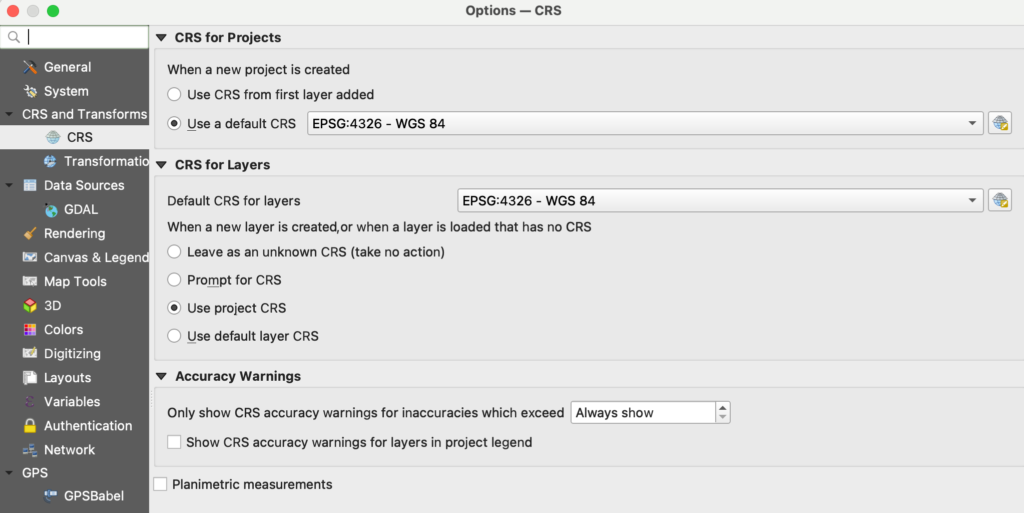
CRS for projects, when a new project is created [x] Use a default CRS of EPSG:4326 – WGS 84
CRS for Layers, Default CRS for layers: WPSG:4326 – WGS 84
[X] Use project CRS